Acting as “nature’s filters” is just the start. The Fraser Wetlands maintain and even improve the quality of water we all enjoy. In the video linked below, Dr. Jeremy Carver explains exactly how the wetlands work, and why it’s so important that we leave them untouched, undeveloped, and able to get on with their work.
The following trio of maps illustrates the importance of the Fraser Wetlands to the entire Stony and Clear Lake community, as well as downstream bodies of water.
The first map shows the location of the Fraser Property – directly opposite the spot where water streams into Stony from Lovesick Lake and other upstream bodies of water, bringing with it higher levels of phosphorous and other contaminants.

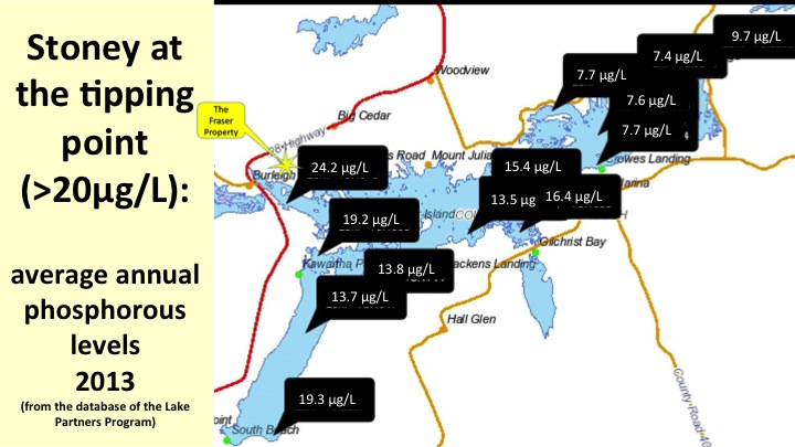
This second map charts the phosphorous levels in Stoney and Clear Lakes. Note that the tipping point – the point at which the level becomes unsafe and can contribute to dangerous algal growth – is considered to be 20 micrograms/L. The point at which water flows into Stoney at Burleigh Falls registers a dangerously high phosphorous level – 24 micrograms/L.
Left to do their work, the provincially significant Fraser Wetland Complex and the adjacent Fairly Lake Island complex have a profound effect on the phosphorous levels and general health of the water we all rely on for recreation, for sustenance, and, not inconsequentially, for secure property values.
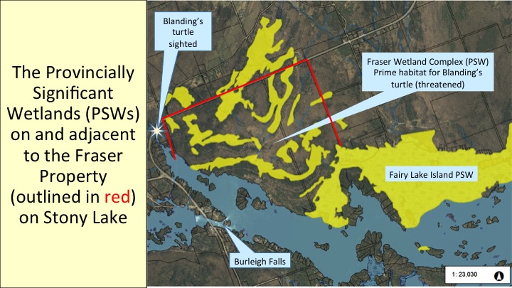
The following map highlights (in yellow) the provincially significant wetlands that occupy so much of the Fraser Property and its extensive shoreline. The 2014 Provincial Policy Statement (PPS)* affirms that no development should take place within 120 metres of a provincially significant wetland, unless it can be “demonstrated that there will be no negative impacts on the natural features and their ecological functions.”**
Ninety per cent (90%!) of the Fraser Property is within 120 metres of a provincially significant wetland.
* Published last year by the Ministry of Municipal Affairs and Housing, the 2014 PPS is the province’s new statement on land-use planning.
* * PPS 2014 2.1
Finally, the following fascinating video illustrates the drainage patterns of the Fraser Wetlands – and how they relate to the developer’s plan to build 60 condominium lots.
Click here for video showing wetland drainage and condo development lot lines.
To view other FFW videos on our YouTube channel, please click here.
As always, thanks for taking the time to consider this material, and please share it widely with your family, friends and neighbours.
FFW
Jeremy Carver, Heather Brooks-Hill, Jen Lewis,
Ben Sämann, John McWilliams, Jennifer David,
Jamie Anderson, Pat Bourne, Mike Ormsby,
Simon + Lorraine Bramson, Scott Wootton,
Catherine Kirk
